TALBOL Geocaching Series
With some spare time at the weekend, I thought that I would get some practise in for my LEL award and I wanted to team this up with a geocaching trail that I’d seen. This way, I could go out and enjoy a day hike, whilst getting in some geocaching.
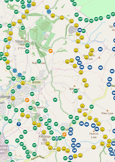
Route
I’d done some hikes in the Peak District for cadets recently and had seen a number of caches with the acronym TAL - on a bit of digging, this appears to be short for The Alien Landings. There seem to be seven different walks (with a total of 382 caches) - the link here has the full details. The cache owner has put a lot of effort in the back story of all of the cache routes.
These caches are located around the Peak District and I had a few to choose from. I decided to do the TALBOL cache route, just outside Bollington. This is the second longest route of the seven, but it’s near one of the areas I’d been nearby. A total of 50 different caches are present on the TALBOL route and there were a number of caches on the route that weren’t part of the series so I think I had about 65 potential caches to collect.
I stuck the route on to my eTrex and downloaded it to my phone in the ordnance survey app and then headed out for the walk. I used a pocket query to download 500 caches around Bollington and saved these to my eTrex and downloaded to Cachly. I also downloaded them in to the Geocaching app on my Android phone as well to see how well that would work offline (it currently has no SIM card, so I can guarantee that it would be offline for the walk!). In the end, I think I ended up doing most of the caching with the eTrex, though that wasn’t without some issues.
Walk
I followed the cache owners advice for where to park. I got there fairly early, I wanted an early start as this would have been the first time I’ve done a caching route, so I wasn’t sure how long it would take. I’d done a hike recently in Edale where I took about 5 hours, so I was expecting perhaps about 6 hours. I didn’t think of it taking as long as it actually did! The car park was by the side of the canal and I was able to get started.
Heading up the canal was simple enough. Finding caches along the canal wasn’t to bad. The canal had a few people jogging along the path and a few boaters out and about, even at 09:00 in the morning.
The route headed up and away from the canal and I headed up in to the hills. By this point, I was down one cache on the route - I couldn’t find cache number 8 on the route, so I’d passed onwards. I was hoping I’d be able to carry on and find a few more.
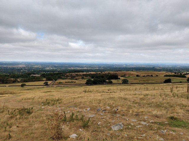
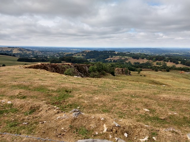
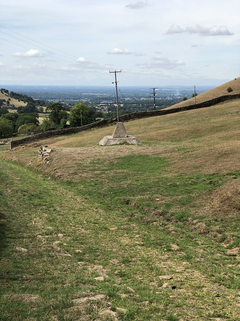
The pictures show the effects of the dry weather we’ve been having recently in the UK - the grass is a bit brown!
I stopped for lunch along the way and looked over the small road, watching the odd car and cyclist past before I continued on. I was getting concerned at this point that I hadn’t brought enough water with me, as I was a few hours in and had already drunk a litre and I had just under a litre remaining. However, the views were worth the walk.
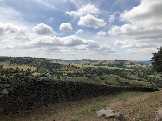
In general, the route itself was fairly easy to follow. I rarely had to dig out the map and use it, however, when I did, there was a good reason, such as the path split into a number of directions and I wanted to ensure that I got the right one. I could have simply put the route on to the Garmin and followed that or put it on to the OS maps app on my phone, but that would defeat of trying to ensure that my map reading skills are getting a workout!
Whilst out walking, there were a number of odd items that were along the route that I could see walking up to them but didn’t have any idea what they were. I had visions of being something to do with bomb shelters (blame this on the nearby cache, Ban the Bomb) or part of the old GHQ line.
Getting close to them, I managed to find out that they were mine caps, capping off the old coal mines that were present on the route. In fact, one of the caps had been fitted with a small model of a coal mine (I did manage to get a picture, but it’s mainly of my reflection!)
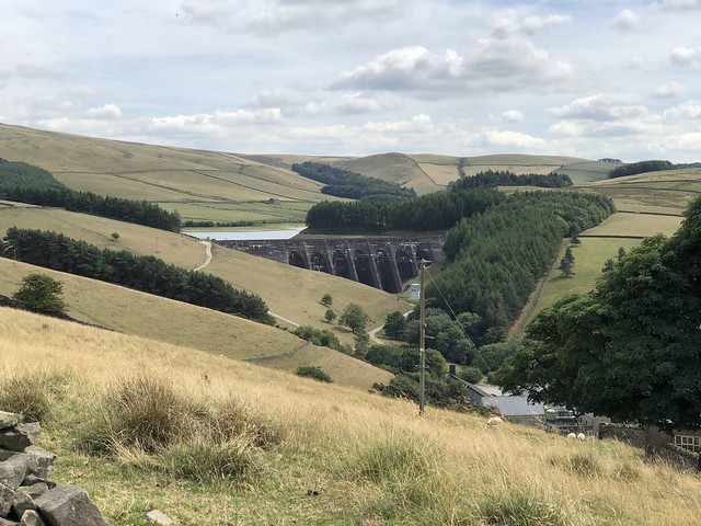
It was a fairly lonely walk - I barely saw anyone on the walk. There were a few groups here and there, but in general, until I got around to Bollington, I didn’t really have to watch out for geocaching muggles! As I approached the Lamaload reservoir, I did stop and ask a nearby house for some water as I had a number of kilometers to go and I was down to about 500ml of water. It turns out I was glad I stopped! I still had some water left when I completed the route, but if I hadn’t had stopped here, there isn’t any way that I’d have got back to Bollington with water.
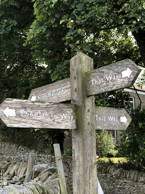
Heading to Bollington from the reservoir, I came across this helpful sign! It was a good job I knew where I was going!
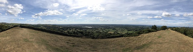
I managed to complete the final hill for the day and was greeted with a fantastic view of the Cheshire plains!
I headed down from the hill and made my way to the canal, where unfortunately, there were a couple more Did Not Finds, but as this was in a higher muggle area, this was more expected than the ones on the hills, so I wasn’t that disappointed. Partly as well because at this stage I was just wanting to get back in the car with air conditioning! Following the canal, I made it back to the car - I’d like to come back and explore Bollington a bit more when I get the chance, as there was an interesting looking cafe near the main mill on the canal but I didn’t stop today.
Outcome
The outcome of the walk was that I almost doubled my cache count total! Now, whilst geocaching isn’t about the numbers (quality, over quantity!), this was a good hike, meeting both the quality and quantity requirement!
I got home and uploaded the caches - as I’d used the eTrex for the hunting, I just uploaded the drafts and was then able to copy and paste my response for most of the logs (which seems to be an acceptable solution for a trial such as this).
Whilst I’ve used the eTrex for caching before, this was the first “real” test of the caching abilities. It was really handy to just be able to mark the cache as found and then move on to the next one, but the underlying software and system is pretty dog slow when compared to a phone. I didn’t want to use the iPhone (and therefore Cachly) to find the caches, as I was tracking my walk with my Apple Watch Series 3, and when the phone is nearby, this seems to make use of the phone for tracking (i.e. location) and therefore, I didn’t want to drain the batteries as quick. I ended up using mainly the eTrex, which would get me near to the cache, but I would end up also grabbing my Moto G6 out of my bag to double check hints or other items whilst I was searching, as trying to do this on the eTrex was slow. I also got towards the end of the walk and was paranoid that the GPS would stop and then corrupt the geocache visit file, rendering my entire walk pretty moot (in terms of caching!) but this didn’t happen and it performed (slowly) with no issue. In fact, being able to upload the cache and then log when I got home made things much easier.
Would I keep the eTrex and use this again in the future? I don’t know. My preference for geocaching is probably firmly in the court of Cachly. It’s interface is straightforward (more so than the Geocaching app) and I’m able to download pocket queries etc with ease. Downloading and saving geocaches offline is also straight forward for uploading later when connected back to a network. The eTrex was just a bit clunky I think. I’m beginning to come around to the opinion that a second phone, with OS maps on, is perhaps far better for what I need than a dedicated GPS. The GPS uses Open Street Maps, which isn’t bad when I’ve got streets, but when I’ve tried it on top of Kinder Scout, it’s proven to be of little help. Having the OS maps there (downloaded in advance!) on a second phone seems to be the better option, even if the battery life may not be as good as the GPS (as this runs on AA batteries).
Whilst not on this route, I’ve also tried to use the eTrex whilst cycling and geocaching, using a handlebar mount, and this hasn’t been great - cycling seemed to be to quick for the position to be kept up to date, which I can only put down to the older nature of the device (the eTrex 20x was released in 2015 - though Wikipedia doesn’t tell me the specs, I imagine that the processor in the Moto G6 is significantly faster, as the rendering of the maps on the phones is so much quicker).
Anyhow, in general, I was able to complete a walk for my portfolio and was able to get myself some geocaches. And I didn’t get lost! So that’s a plus! Shows that I can just about read a map!